GES197 - North West Storm Relief, London
I've explored Storm Drains before, however none quite as huge as this one. The size of the pipe is larger than most other drains halfway down its length, rather than just towards the outfall. The force and power of water coming down here in full flood would be beyond terrifying. It's why I've been avoiding it for some time. Storm drains remain something of a mystery to me, from what I can gather, they fill when regular CSO sewers overflow. This means when water comes down a Storm Relief, it never trickles, it roars! When you hear of people dying in sewers, it's normally a storm drain. With that in mind, I was cautious to make sure I knew where I could exit in the event of a problem. Other storm drains in London have been known to fill to the ceiling within an hour, on a bright sunny day.
This is a map of the North West Storm Relief (NWSR), starting at point 1, and ending at the River Thames at point 6.

This is the 'source' of the NWSR, up in Kilburn. It's main source of water up here, is the Ranelagh CSO (Point 1 on Map). This runs by at the top of the ladder. The passage on the right is about 2m long, and ends with a drop shaft from the Ranelagh CSO. The pipe on the left leads south and is the mainline pipe for the NWSR. On the left behind the camera, is another much smaller pipe leading straight off into the distance.

The ladder on the right in the above picture, leads to another ladder up a large shaft to the surface. The picture below shows two levels above the Ranelagh, with large wooden weir planks put up. The small hole above the ladder leads up to another flat area and then a manhole to the surface. Behind the camera is a set of stairs down to the Ranelagh upper level.

Walking up the Ranelagh overflow on the right above, we came to the steps which lead up to the Ranelagh. The smaller tunnel on the left is another overflow from the same chamber. When the Ranelagh floods, it would come down the steps and out the pipe on the left. More about the top of the steps can be found in the write-up for the Ranelagh CSO, last handful of pictures here.

After the Ranelagh overflow junction above, the NWSR takes on a brick pipe for its course. Here we see steps up to a spur of the NWSR, that helps with the overflow of the Interceptor, which we'll meet a bit later. (This is point 2.5) on the map.

The NWSR branch out to the Mid Level Interceptor (as seen above). A manhole exit on the left, and in the centre, some residue from the last time it flooded.

Moving downstream, the pipe keeps its size and shape (as seen at the back of the photo below) until it hits Notting Hill, in the region of Portabello Road, which passes above us here. The Mid Level Interceptor passes overhead here, and the small tunnel on the right goes for about 20m before stairs take you up to it. The small tunnel on the left is a branch of the NWSR that goes out to join the Wood Lane Sewer in Harlesden. I've walked from there into the junction seen below on a previous trip. the pipe was crouchy all the way, with pockets of bad air. (Point 3 on the map).

Turning around from the above pic, a set of stairs leads down, as the NWSR drops down from Notting Hill to the Thames floodplain in West Kensington.

The passage on the left, two pics up, that leads to the Wood Lane sewer, once past the weir.

Up the passage on the right in the junction under Portobello Rd. Up the steps is the interceptor (Mid Level), on the immediate right, another set of stairs leads up to a ladder and manhole. As well as another set of stairs that this time, lead down to the Interceptor.

At the top of the steps above, The deceptively quiet Mid Level Interceptor, takes the nastiest of sewer items away to Beckton.

The steps down from the Portabello Rd exit to the Mid level Interceptor, just behind the camera is a ladder out to the street.

Continuing further down from Notting Hill to West Kensington, the pipe size is considerable for a drain. In the picture I’m looking upstream to Notting Hill. As with the Portabello Rd junction, this is the same layout. On a map, it forms a huge figure of eight. The pipe on the left goes around in a semi circle and comes in at the Portabello Rd Junction (the one on the left). Halfway around the semi circle is a spur that heads to the Wood Lane sewer in Harlesden. The pipe on the right forms the bottom of the figure of eight, although less of a semi circle, more of a triangle. It rejoins the NWSR lower down. (This is the middle of the figure of eight on map between point 3 & 4).

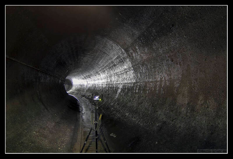
Looking south/downstream, over the small weir, the NWSR goes back to concrete lined. A clean looking depth gauge next to manhole exit.

Rather than walk down the similar looking NWSR mainline, we opted to take the triangle diversion. Something Residues wasn't too keen on, as it involved crouching for 500m. Oddly it was very dry inside, note the ceiling and sides.

Towards the end of the triangle was an exit we took. Another 30m, and we would re-join the NWSR mainline tunnel. However that would have to wait for another trip.

Back for another trip, and continuing down the crouchy pipe for 100-200m we exited above. We came to a dead end, which I wasn't expecting. What little water there is diverts off to the right here. (This is point 4 on the map)

The diversion dropped into a lower smaller tunnel. No idea where it went.

We crouched all the way back to the exit lid, and came out. I had a number of other lids to check in the area, and hoped to pop in further downstream. After finding a few lids for tiny local sewers, we came across one for the NWSR again. It had a sealed airtight lid beneath the manhole which was a bit scary. I popped the sealed lid and it dropped and clanged against the side of the of the access vent. A ladder dropped down 15m or so into the gloom. We let it vent for 5 minutes, to allow a bit of oxygen to get down there. I then set off down the ladder. Stepping through some muddy goop at the base of the ladder, it was then into a dry tunnel with a musty element in the air. I didn't feel confident about going for a wander without a gasometer. Just out side the side access point, was a ramp in the tunnel. This is looking upstream from the ramp. (This is point 5 on the map)

The side exit and the ramp in the tunnel, a feature I hadn't seen before.

The tunnel continues off downstream towards Hammersmith. With the likelihood of sealed airtight lids being in use further downstream, it would be a foolhardy trip to go further. We would have to look for another lid to drop in downstream.

Thanks to Residues for company and persevering with the crouching!
A FINAL TRIP INTO THE NWSR
By accident I had found a lid that looked like it sat on the NWSR on the Map, it was halfway between the last access lid we found, and the end chamber by the Thames. I pulled up the lid to find a sealed lid below. This must be the NWSR! I pushed the handles to one side and...nothing. I thumped the lid with my sole as hard as I could without risking falling in should it give way. But alas, nothing. It had rusted tight.
I set about finding the elusive end chamber of the NWSR with Ojay in tow. It required some extra information from a well known London explorer. I had already been to the location one needs to get too before, but had over looked the crouchy tunnel that lead off under an opened penstock. This time though, it was a case of crouchy crouchy to get to the NWSR tunnel. Ojay set off first, and reported back that it stank fairly badly of H2S (rotten eggs). Not a good sign. However he made it the 30m or so to the entrance into the NWSR. I moved slowly along the crouchy tunnel, and was soon stood upright with him in the 3-4m high tunnel. It looked similar to how I'd left it under Holland Park in the above shot. Only there was more clag here on the sides. (This is 100m from Point 6 on the map). The photo below was taken with the Canon 40mm pancake lens, which I love!!

Moving around a bend, lit here by Ojay taking a shot.
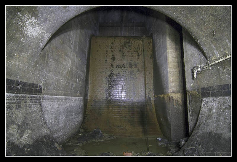
We came to the end chamber. A 4m high wall with a trickle of water running down it. To the right just visible in the recess is a ladder to the bank of the Thames. Sadly it was a sealed lid.
Finally, two years after I first entered the system, I had completed it. Apart from that bit before the end, but then, it was probably all very samey!
Thanks to Ojay for gas meter observations on this last part of the trip.
Add comment
Comments